Quantcast


Vermont has bike trails, tours, and equipment for a fun biking vacation

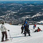
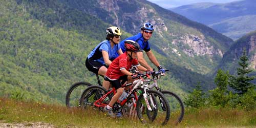
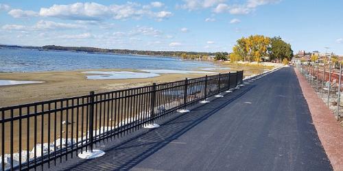
Vermont offers plenty of biking for people of all ages and abilities. Vermont has biking trails, some on old rail trails, biking tours, bike rentals and gear and equipment. Biking can be a great fun family vacation with the kids. When your appetite begins to roar, tuck in to the menu at a satisfying Vermont diner.

Biking & Bike Trails in Vermont

Follow these links for : Campground Information - Hiking Trails - Beach Areas - State & Local Parks
Biking by the Lake - Lake Morey Resort - Fairlee, VT
Lake Morey Resort

82 Clubhouse Road Fairlee, VT, 05045 Phone: 802-333-4311 Toll-Free: 800-423-1211

Vermont, and this four-season lakeside resort, welcome bikers of all ages, abilities

Vermont is known for welcoming bikers to its scenic countryside, hills, valleys and mountains, so it’s no surprise that the Lake Morey Resort offers bikes for guests to borrow as they set out to explore this breathtakingly beautiful area. Bike five miles along the shore of Lake Morey or ask at the front desk about other nearby biking trails. You can pedal across the Connecticut River, wind your way through hills and pastures on a mix of pavement and dirt roads, taking in views of cottages hidden in the hillsides. Ask about the Bike and Brew package in the fall, which features a trip to Lyme, N.H., for a pint of ale! Come back to the resort to relax in the pool or sauna.
Newport Waterfront Bike Path - Discover Newport, VT
Discover Newport Vermont

Newport Waterfront Recreation Path

The Newport Waterfront Recreation Path, located on Lake Memphremagog, is a great trail that visitors of all ages can enjoy. This waterfront recreation path is great for biking as well as walking, running, birdwatching or just exploring nature. The Path starts at the Newport, VT Gateway Center/City Docks downtown and follows the lakefront through Pomerleau Park, across the old railroad bridge, in front of the Waterfront Plaza to Prouty Beach, across the new connector bridge onto Bluffside Farm, and eventually connects to the Beebe Spur Rail Trail that hugs the eastern lakeshore of Memphremagog five miles to the Canadian Border. Maps of the trail are available at downtown businesses and the Information Center at the entrance to Gardner Park, and also on DiscoverNewportVT.com.
Lye Brook Falls Trail - Manchester, VT
Lye Brook Falls Trail

The wooded Lye Brook Falls Trail runs for 2 miles through the Lye Brook Wilderness of the Green Mountain National Forest near Manchester. The blue-blazed hiking trail follows the bed of a former logging railroad up a slope that runs alongside the Lye Brook.
Trail access: Parking is available at the northern end of the trail at the end of Lye Brook Access Road. The trailhead is located to the east of the parking lot. - Trail Map
Delaware & Hudson Rail Trail

Along local roads Castleton and Poultney, West Pawlet and Rupert, VT Phone:

This bike trail, on a former railroad bed, is 20 miles long and divided into two sections. The two sections in Vermont are separated by a length of trail in New York State. The Vermont sections stretch between between Castleton and Poultney, and between West Pawlet and Rupert. The trail passes through pretty countryside and there are places along the trail to have a picnic, fish, and stop for refreshments at stores.
The trail is open to walkers, bicyclists and horseback riders, snowshoers, skiers and snowmobiles. Trail access for the northern section is at Castleton State College or along Main Street in Castleton and in Poultney village adjacent to the old train station on Depot Street. Trail access for the southern section is at West Pawlet village on Egg Street and at the connection of Route 153 and Hebron Road.
Maps and guide
Missisquoi Valley Rail Trail - Photo Credit Steve Schwinn
Missisquoi Valley Rail Trail

Total Length: 26.4 Miles

Standing in the former tracks of the Central Vermont Railway, the Missisquoi Valley Rail Trail continues an historic link between St. Albans, Sheldon, Enosburgh, East Berkshire, and Richford. Farm-to-village commerce and international trade flowed through the corridor along a plank road in the late 1800s. It continued by rail until a derailment permanently closed the route in 1984. The State of Vermont and local citizens began converting the corridor to a multi-use trail in the early 1990s. Many traces of the railroad “Milk Run” days still exist along the trail for you to discover, including train stations, rail sidings, and creamery foundations.
This 10-foot wide multi-use path is paved mostly with crushed limestone, with a relatively level grade. See website for access points.
East Branch Trail

The East Branch Trail is a 5-mile backcountry pathway built on a former logging railroad bed. The remote, heavily wooded trail lies just north of the Searsburg Reservoir and Deerfield River in the Green Mountain National Forest. At either end, you can connect to the Catamount Trail (Section 3), a 300-mile cross-country skiing route that spans the length of Vermont.
Trail access:
From Wilmington, travel 5 miles west on Route 9 to Somerset Road. Turn north onto and travel about 2 miles to the East Branch Trailhead.
South Burlington Bike Path - Photo Credit Traillink
The South Burlington Recreation Path

Total Length: 26 Miles

This path provides bicyclists with a new and exciting way to experience the beauty of Vermont. The trail (which is not continuous but contains stretches of up to 4.5 miles of uninterrupted paved path) takes bikers all over the city, through neighborhoods and commercial districts, to corn fields and the banks of beautiful Lake Champlain.
Cross Vermont Trail - from Wells River to Colchester, VT
Cross Vermont Trail

Total Length: 30 Miles

The Cross Vermont Trail is a work in progress; a projected 90 mile path connecting towns across the state from Lake Champlain to the Connecticut River. There are currently 30 miles of completed trail suitable for bicycling; however, tires with higher-grade tread are recommended, as some of the trail is gravel. - Trail Map
Burlington Greenway Bike Path - Greater Burlington, VT
Burlington Greenway Bike Path

Total Length: 7.6 Miles

Burlington's Greenway, also known as the Island Line Trail, is a 7.6 mile recreational route that runs from the southern end of Burlington at Oakledge Park to the northern end at the Winooski River, where it connects via the bike path bridge to the Colchester Bike Path. The Bike Path rides along the Lake Champlain shoreline, offering wonderful views of the lake and the Adirondack Mountains to the west. The bike path links six major waterfront parks, along with the Burlington High School and the central Waterfront district.
Lamoille Valley Rail Trail in Vermont
Lamoille Valley Rail Trail

Following Route 2 and Lamoille River St. Johnsbury to West Danville, VT Phone:

At 93 miles in length, the Lamoille Valley Rail Trail crosses northern Vermont from the Connecticut River Valley to Lake Champlain. This trail is open and in use in all four seasons of the year. The full trail falls into two major sections: Phase 1A runs 15 miles through forests and past farm from St. Johnsbury to Joe’s Pond in West Danville, and Phase 1B covers 17 miles and follows the Lamoille River from Morrisville through Hyde Park and Johnson, linking to Cambridge Greenway and moving on to Jeffersonville. - Full Trail Map
Cycle the City
Cycle the City

This self-guided bicycling loop guides bikers you along Lake Champlain following the Island Line Trail, also known as the Burlington Greenway. The loop also passes through architecturally interesting and beautiful areas like the University of Vermont (UVM) and Champlain College neighborhoods. This website will get you onto Burlington-area bike trails with every bit of detail and support you could possibly need. Cycle the City is part of the Lake Champlain Bikeways, 1,100-mile network. - Guide (PDF)
West River Valley Trail - Southern Vermont - Photo Credit Ellen Waagin
West River Valley Trail

Various access points Brattleboro, Dummerston, Newfane, Townshend, Jamaica and South Londonderry, VT Phone:

A 3.5 mile multi-use pathway on a former railroad bed parallel to the West River. The Lower Section of the West River Trail begins in Brattleboro near the Marina restaurant and follows the West River to the old granite quarry in Dummerston. The trail is flat. It is popular with runners, bikers, and walkers. About one mile from the Marina trailhead is the Riverstone Preserve.
Roads around West Dummerston can be used in combination with the West River Trail for extended bicycle riding. From the Marina Trailhead, you can pedal out the West River Trail and then follow Rice Farm Road and Quarry Road to the West Dummerston Covered Bridge. There is a park-and-ride lot on the west side of the bridge, just off VT-30. The distance is 6 miles one way. - Lower Section Trail Map (PDF) - Upper Section Trail Map (PDF)
Stowe Recreational Path - Stowe, VT
Stowe Recreational Path

Total Length: 5.3 Miles

Completed in 1989, this 5.3-mile paved trail starts in Stowe Village, next to the Stowe Congregational church, winds its way through the woods and meadows, and crosses the West Branch River 11 times on arched wooden bridges. Numerous shops, lodges, and restaurants are accessible from the path.