Quantcast


Southern Vermont has state parks and rail trails just perfect for biking

Lye Brook Falls Trail - Manchester, VT
Lye Brook Falls Trail

The wooded Lye Brook Falls Trail runs for 2 miles through the Lye Brook Wilderness of the Green Mountain National Forest near Manchester. The blue-blazed hiking trail follows the bed of a former logging railroad up a slope that runs alongside the Lye Brook.
Trail access: Parking is available at the northern end of the trail at the end of Lye Brook Access Road. The trailhead is located to the east of the parking lot. - Trail Map
East Branch Trail

The East Branch Trail is a 5-mile backcountry pathway built on a former logging railroad bed. The remote, heavily wooded trail lies just north of the Searsburg Reservoir and Deerfield River in the Green Mountain National Forest. At either end, you can connect to the Catamount Trail (Section 3), a 300-mile cross-country skiing route that spans the length of Vermont.
Trail access:
From Wilmington, travel 5 miles west on Route 9 to Somerset Road. Turn north onto and travel about 2 miles to the East Branch Trailhead.
West River Valley Trail - Southern Vermont - Photo Credit Ellen Waagin
West River Valley Trail

Various access points Brattleboro, Dummerston, Newfane, Townshend, Jamaica and South Londonderry, VT Phone:

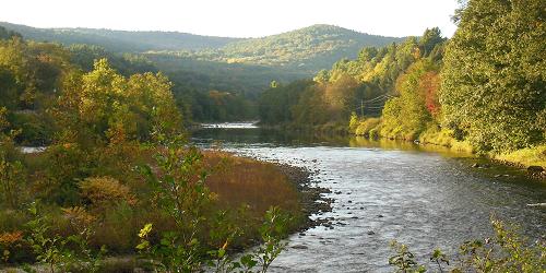
A 3.5 mile multi-use pathway on a former railroad bed parallel to the West River. The Lower Section of the West River Trail begins in Brattleboro near the Marina restaurant and follows the West River to the old granite quarry in Dummerston. The trail is flat. It is popular with runners, bikers, and walkers. About one mile from the Marina trailhead is the Riverstone Preserve.
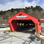
Roads around West Dummerston can be used in combination with the West River Trail for extended bicycle riding. From the Marina Trailhead, you can pedal out the West River Trail and then follow Rice Farm Road and Quarry Road to the West Dummerston Covered Bridge. There is a park-and-ride lot on the west side of the bridge, just off VT-30. The distance is 6 miles one way. - Lower Section Trail Map (PDF) - Upper Section Trail Map (PDF)