Quantcast


Biking & Bike Trails in Northern Vermont

Missisquoi Valley Rail Trail - Photo Credit Steve Schwinn
Missisquoi Valley Rail Trail

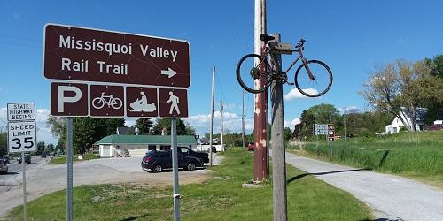
Total Length: 26.4 Miles

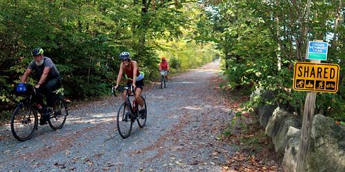
Standing in the former tracks of the Central Vermont Railway, the Missisquoi Valley Rail Trail continues an historic link between St. Albans, Sheldon, Enosburgh, East Berkshire, and Richford. Farm-to-village commerce and international trade flowed through the corridor along a plank road in the late 1800s. It continued by rail until a derailment permanently closed the route in 1984. The State of Vermont and local citizens began converting the corridor to a multi-use trail in the early 1990s. Many traces of the railroad “Milk Run” days still exist along the trail for you to discover, including train stations, rail sidings, and creamery foundations.
This 10-foot wide multi-use path is paved mostly with crushed limestone, with a relatively level grade. See website for access points.
Stowe Recreational Path - Stowe, VT
Stowe Recreational Path

Total Length: 5.3 Miles

Completed in 1989, this 5.3-mile paved trail starts in Stowe Village, next to the Stowe Congregational church, winds its way through the woods and meadows, and crosses the West Branch River 11 times on arched wooden bridges. Numerous shops, lodges, and restaurants are accessible from the path.
South Burlington Bike Path - Photo Credit Traillink
The South Burlington Recreation Path

Total Length: 26 Miles

This path provides bicyclists with a new and exciting way to experience the beauty of Vermont. The trail (which is not continuous but contains stretches of up to 4.5 miles of uninterrupted paved path) takes bikers all over the city, through neighborhoods and commercial districts, to corn fields and the banks of beautiful Lake Champlain.
Cycle the City
Cycle the City

This self-guided bicycling loop guides bikers you along Lake Champlain following the Island Line Trail, also known as the Burlington Greenway. The loop also passes through architecturally interesting and beautiful areas like the University of Vermont (UVM) and Champlain College neighborhoods. This website will get you onto Burlington-area bike trails with every bit of detail and support you could possibly need. Cycle the City is part of the Lake Champlain Bikeways, 1,100-mile network. - Guide (PDF)
Cross Vermont Trail - from Wells River to Colchester, VT
Cross Vermont Trail

Total Length: 30 Miles

The Cross Vermont Trail is a work in progress; a projected 90 mile path connecting towns across the state from Lake Champlain to the Connecticut River. There are currently 30 miles of completed trail suitable for bicycling; however, tires with higher-grade tread are recommended, as some of the trail is gravel. - Trail Map
Burlington Greenway Bike Path - Greater Burlington, VT
Burlington Greenway Bike Path

Total Length: 7.6 Miles

Burlington's Greenway, also known as the Island Line Trail, is a 7.6 mile recreational route that runs from the southern end of Burlington at Oakledge Park to the northern end at the Winooski River, where it connects via the bike path bridge to the Colchester Bike Path. The Bike Path rides along the Lake Champlain shoreline, offering wonderful views of the lake and the Adirondack Mountains to the west. The bike path links six major waterfront parks, along with the Burlington High School and the central Waterfront district.